As scaq makes the transition from Michigan to Colorado, we thought it would be appropriate to create a new blog to record our new adventures. We'll keep the Michigan scaqabout blog available as long as Google lets us, so if you'd like to review our history, feel free to explore the Archive section to the right.
The new blog will be called "scaqaboutwest" and you can find it by clicking here.
07 April 2012
04 March 2012
Buffalo Creek
Last night I was too verbose in my blogging, so out of respect for you, reader, I'll keep this short.
I hadn't initially planned on it, but I went back to Pine Valley again. This time I went a little further down the road and started at Buffalo Creek. The first part of the ride followed Buffalo Creek Road and was a snowy and icy in places; unrideably so in some spots.

Baldy Trail took me north and up, away from the creek. Up, up, up! I love to climb! There were some nice flat slabs of granite around mile seven that beckoned for a little break. The slabs might be the top of a huge dome, I suppose.

Baldy was gravelly, but soft in partial shade and frozen in full shade. Millers Trail is a double track along a wide flat ridge in the trees. It was a gradual descent, but there was too much deep snow for it to be much fun.

Charlie's Cutoff, which I had done yesterday going uphill, wasn't much better going the other way. There was too much snow and ice. It was fun in a challenging endurance sport sort of way, but it most definitely was not like going down the curly slide at the playground. Homestead was better; it playfully twists over and among granite boulders and slabs in a gradual descent. It's a definite favorite, but a with a warm evening and a warmer day today, it was also a little softer and wetter than it was yesterday.

I passed the site of yesterday's crash and reached Sandy Wash Trail, which was mostly dry and almost entirely downhill swoopiness; a roller coaster ride to back down to Buffalo Creek, which made up for quite bit of the grunt work I'd done over the previous 12 miles. Check out the Garmin log to see how much faster those last few miles were, and if you haven't before, try using the Player on the Garmin site.

The continual transition from slush to gravel made a mess of my bike. The worst was really the descent down Buffalo Creek road as I returned. The air was warm, the snow was thawing, and the road was turning into a stream.

I hope to make many return trips to this area. It would be so much more fun to do it with the whole of scaq instead of by myself. However, given the intensity of the climbs, we'll wait to attempt it until everyone is well-acclimated and has logged some miles at lower elevation on some flatter trails. This is not what I'd call a good starter ride.
The next two weekends I'm back in Michigan where winter still holds a firm grip, so no more mountain blogs from me for a while.
The next two weekends I'm back in Michigan where winter still holds a firm grip, so no more mountain blogs from me for a while.
Pine Valley Ranch Trails
Pine Valley Ranch Park is a Jefferson County Open Space park about 30 miles southwest of Denver, and 50-ish miles from my office in the Denver Tech Center (usually just called "DTC"). I picked this ride today because all the trail conditions info I've been watching on the internet suggested it would be dry and ready to ride. Other closer trails have had more snow recently.
I put in a little time in my office working on a report while I waited for the sun to come up and the air to warm. A little before noon, I grabbed my Nickel and hit the road, stopping at Chipotle for a big veggie burrito to power me through the ride. I knew it would be an hour between the time I at that burrito and the time I actually started riding -- especially since I found that my bike had a flat front tire (two thorns!) when I picked it up from it's parking spot near my office. The Pine Valley Ranch Park looked very nice, being sort of tucked into a cozy, rock-lined valley. It would be great spot for a picnic and a walk on a warm sunny day.
Once I got a new tube installed, I put on my helmet and Camelbak backpack, and headed for the Buck Gulch Trail. Buck Gulch Trail starts at bridge over the North Fork of the South Platte River downstream of the lake, and quickly leaves the Jefferson County Park to enter the Pike National Forest. I'm glad there was a bridge.

Buck Gulch is a long hard grind up a loose gravelly surface. I'll emphasize "up," too, because it climbs right at 1000 ft in just over three miles, the worst being the first two. You can see from my Garmin log that my progress was very, very slow crawling up this hill. And I could feel that burrito. A very large fire burned this area in 1997 and in most places the trees are still just skeletons. There were lots of downed trees across the trail, too, many of which required a dismount to get across. Getting started on a steep gravel his is always a fun challenge. I took this photo while I made a phone call home to talk to Abbey. It was a good excuse to rest. This would have been right at the end of the second mile.

One reason this series of trails is rideable early in the season is that the surface is pretty much all gravel. There's not really much in the way of soil here, so there's nothing to make mud. Even in the few places were it was damp, it was more like wet sand than mud. The last little bit of Buck was downhill and a tremendous relief after the long steady climb. Skipper Skipper was just a blast, although I had to take it a little slower than would necessary later in the season because of the snow and ice patches that kept appearing unexpectedly in the trail.
My guide book suggested taking Charlie's Cutoff to the south to do the second loop of the figure eight counterclockwise, but I did it the other way accidentally, taking the Homestead Trail east instead. This was actually fine because the riding on Homestead in that direction was great. The trail took me across all sorts of big flat smooth rocks, which was really fun, and there even a few drops and little ledges in places, although nothing like what we had seen in Moab.

I guess I was having just too much fun going slightly downhill on Homestead and I missed the turn for Charlie's Cutoff. There was a hiker behind me who did the same thing, so it wasn't hard to do. I actually suspected that I had missed the turn, but the downhill on Homestead was so fun I just kept going. Once I crossed the creek north of Baldy Peak, I knew I'd gone too far. There was a trail junction where I stopped, so I took a little break and review my map and my options. Homestead was great coming down, so why not head back up it and go through those rocks again?
I was feeling a little tired, and with the recognition that I'd come a full mile past my turn and almost 200 ft downhill, I knew this was going to turn into a tough ride. What I did not need was a crash. The little creek I'd crossed right before I stopped had a steep bank on the south that was packed with snow and ice but I'd had no particular problem climbing up it. Going down however, I couldn't get my front wheel to grab and track in the snow, and of course braking on ice isn't very effective no matter how good your disc brakes are! So I gained uncontrollable speed in what seemed like just a couple of seconds, and then found myself veering off course to my right towards a large downed pine tree with a full complement of dry, branches pointed straight at me like spears. Most of them smashed out of the way as I plunged into the tree at about 10 mph (according to the Garmin log at that point). My Camelbak caught most of the force of the branches, but as my body came to a halt among all those spears, I immediately found myself looking around to see if I had any severe puncture wounds. Finding none, I quickly got on my bike and finished riding down the slope and crossing the creek. For some reason, it always seems like the quicker I can get back on the bike and start pedaling, the less I must have been hurt. After a crash like that, it often takes a while for the adrenaline surge (or whatever) to wear off, and that when I usually start to know where and how bad my injuries are.
I kept pedaling, but the crash had sapped my strength, or at least my resolve. Going up Charlie's Cutoff going west was seeming like a bad idea. At least half of the tread was snow and ice, so forward and upward progress was slow. I hit ten miles at that point, and the whole ride was only supposed to be 12. Eventually I made it to the junction with Strawberry Jack's, and felt relieved to turn downhill. Misfortune mocked my relief as I promptly end-o'ed in a snow drift! I was moving too quickly across a little icy snow patch when my front tire sank, and instantly I was over the bars and on the ground. Fortunately, and end-o on soft snow is actually kind of fun and not generally painful. I laughed at myself and my bike sprawled across the snow.
The snow on Strawberry Jack's soon gave way to course gravel, still with occasional snow patches just to keep me on my toes. Toes, which, were completely numb at this point, along with my fingers. As I descended -- maybe due to the wind chill from speed or maybe from cold air sinking into the valley -- I was cold. But I was going downhill again, and I was really tired, so I was happy.
This spot is on Strawberry Jack's, just before the beginning of the fun, fast, and cold descent.

The parking lot had only three cars when I got back around 4:30 p.m.

I guess my Camelbak didn't stop all of the branches. One seemed to have made it through my favorite jacket, my favorite wool shirt, and a little of my skin.

29 February 2012
Lunch Loops
Sunday was not a cycling day for day Heather since she had a nine mile training run on her schedule. She was nice enough to offer to stay home with Cailan in the morning while Chris and I went and rode some of the Lunch Loops trails. The Lunch Loops trails are just inches outside of Grand Junction. In fact, except for the challenge of riding down the road with Utah, it would have made almost as much sense to ride to the trails as to drive.
If I've got this figured out right, we actually started at the Tabeguache Trailhead and headed southwest until we reached Pet-e-kes and then climbed up to the Holy Cross trail. We followed Holy Cross to Holey Bucket, then the Ali Loop, Ali Alley, maybe around Curt's Lane, and then finished out with Kid's Meal. It's quite a network of trails, and it was good to have an experienced guide.
Click here to see the Garmin log. Of course, I thought I started the Garmin when we set out, but did not, so I missed the first segment of the ride.
The trails were very fun, and on a much tighter ribbon than the wide jeep road the day before. It was also very nice to be able to follow my guide, Chris, through all of the really difficult sections. I would simply watch him go through and then do it myself by following his path. I must admit that there were quite a few spots, especially going up Holy Cross, where Chris cleaned sequences of obstacles on the trail and I did not.
The trails around Grand Junction are not quite so rocky as what we'd ridden the day before in Moab. The Lunch Loop trails comprise quite a bit more clay and sand, but there is plenty of exposed rock to make for some good challenges. The scenery is nice, stark, and the features of the landscape are more subdued and maybe not quite so creatively sculpted as those in Moab.

The Holy Cross trail presented some really fun challenges. Most of them were rideable. Some of them appeared to be possibly rideable, but not obviously so; I tried a few of those. And there were those that were clearly not rideable by the likes of me; Chris tried a few of those.
The images below were some that Chris and I took after spending some time scouting out the feasibility of riding this obstacle. My initial thought was, 'No way!' But after we walked around it, we began to think it really fell into the second category above: possibly rideable. Chris decided to give it a shot, so I got out the camera to capture his fall. As it turns out, the only tricky part is getting lined up and clipped in to get started, since the trail comes out of a steep drop and turns sharply right before hitting the first big rock. Once you're on the rock, you turn left and drop onto the second rock and then just roll on through. Chris liked it so much he did it twice.


Chris made it look so easy I had to try it myself, while Chris took pictures. You can see in the first picture how the trail turns sharply as it approaches the first rock. It took me a couple of tries to get going. Then I was on first rock...
.jpg)
... and carefully turning down and left...
.jpg)
... and then just rolling on out.
.jpg)
Somewhere near the end, where Curt's Lane turns back toward the parking area at the top of a bluff we had a great view of the bike park and trailhead.

And then a quick lunch and I drove back to Denver with two white bicycles on my truck.
Amasa Back 40th
Last weekend I made another trip to Grand Junction. I had three primary and not-entirely-distinct goals for this trip: One was to help Heather and her family celebrate her 40th birthday. Another was to go to Moab to pick up a used bicycle I found for Quinn. Another was to ride by own bicycle in Moab, which, despite calling myself a mountain biker, I'd never done.
After having a great time meeting and talking (bikes) with a bunch of Heather and Chris's friends at Heather's birthday party Friday night, we got up Saturday morning, loaded the bikes into the truck, and Heather, Chris, Cailan, Bobby, and I drove to Moab Cyclery in Moab where Quinn's new bike was awaiting us. Quinn had pretty much outgrown his little 20-inch wheel bike you've seen him on so often, and we've been watching for a replacement for the last year or so. This Santa Cruz Juliana, has 26" wheels and extra small 13.5-inch frame. The XS Juliana had been one of our preferred options for Quinn, but it took us a while to find the right one. Anyway, here it is, photographed back at Heather and Chris's house. With white paint and the same decal design, it looks very much like my Nickel, which is off to the right. The Juliana had a good first year of life in Moab, so it's a bit scuffed up, perhaps mostly from transport to and from the trail head, but it appears to be in excellent mechanical condition. And it sure looks nice here. Poor Quinn has a new bike and won't even get to touch it until he comes out to Colorado to visit me in a month. Even then, after the visit, he won't get to take it home! Maybe it will provide some incentive to make him want to move out here to Colorado with me.

While we were at Moab Cyclery buying the bike, we had a PBJ lunch at a table in front of the shop while we waited for friends Heidi and Marie who were joining us for the ride.
The Amasa Back trail climbs about 1000 ft mostly on sandstone in the middle of big meander of the Colorado River. It's supposed to be a jeep trail, but I'm betting that most of the year it seems more bicycles than jeeps. Of those bicycles, what portion are tandems?
Most of the trail is easy enough to ride. It is only moderately steep, climbing 1000 ft in about five miles, and much of the tread is smooth sandstone. Despite the name "slickrock," the sandstone is anything but slick. It's actually quite grippy. It feels somewhat like medium grit sandpaper and provides plenty of traction for pedaling up very steep inclines. Of course, that means you have to have strong enough legs and lungs to maintain power to the tires for those climbs.
The biggest challenge presented on the trail are the boulders and rock ledges. Some of them are just too big to climb, others are somewhere in between and present a fun challenge. Often the ledges and boulders come in rapid sequence making for some really tricky, technical riding. Going up those ledges was sort of like rock climbing; picking the best path with careful tire placement and balance, and then powering up at just the right moment. Going down required a different strategy; it was less like solving a puzzle than it was like flying - or even falling. Okay, on to the pics...
Heather and Chris pedaling hard on sandstone:

Heather and Chris climbing on sandstone:

Heidi and Marie grinding up a long flat on sandstone:

In some places the trail was too close to the edge. We survived, but I was not comfortable pedaling close to a cliff!.

Heather and Chris on sandstone, pulling off an especially impressive climb:

Heather and Chris at the top with my Nickel:

It was definitely one of the most scenic rides -- if not the most scenic ride -- I have ever done. If only the rest of scaq could have come along (although then those sheer cliffs really would have scared me). It was challenging, too, but we moved at a reasonably gentle pace so it was not difficult or particularly dangerous. Even with five people and four bikes in our group, in the end we all were somewhat surprised that there had not been a single crash on the entire ride.
Click here to see the Garmin log for the ride. You'll notice it took us two hours to get up and only one to come down.
31 January 2012
Horsethief, Mary's, Rustler's, and Rabbit Valley
Over the weekend I took a short trip even further west to do some mountain biking in the Grand Junction area with our western slope relatives. I left Friday after work and drove across the mountains on I-70 in the dark. The roads were a little icy in the high mountains, which made the drive a little stressful, but I didn't run into any problems. I got to Grand Junction late, unloaded my biking gear from the Nissan, and spent just a few minutes talking and winding down before getting to sleep.
I awoke to a hot breakfast of french toast and good coffee, as promised, and then we packed the gear into H&C's Nissan to hit the trails. It was quite cold that morning, a good bit below the freezing mark, so we dressed warmly and left Cailan with his grandma.
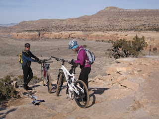
Looking for the driest trails we could find, we went northwest of I-70, past Fruita, to the Kokopelli parking lot where we could access several trails from a single starting point. We began by heading up a moderately steep and rocky trail, Mary's Trail, until we reached a rock shelf overlooking Horsethief Bench.

The descent from the shelf to the bench is quite steep. It may look like we're on the edge of a cliff (below), but it's actually the beginning of the descent. Most people don't ride it. Most people who try probably end up breaking something. Today it was especially treacherous because it was covered in ice. Of course, I didn't get any photos of the actual descent because I was too busy trying to descend without getting killed or dropping my bike off the boulders. Below, Heather holds my Nickel and talks to Utah while I take pictures before we descend.
Most of the Horsethief Loop was plenty dry, but some of the sections on north-facing slopes were not. This picture shows a snowy north-facing slope in the near background. Heather and Chris are climbing on the tandem.

After doing Horsethief, we carried the bikes back up to the shelf and continued around on Mary's Trail. The section below was undoubtedly the most exposed section of trail we rode. It actually looks worse in this picture than it really seemed, although one would not want to take a wrong turn here, or even look away at the scenery for a half second.

We stopped for a snack where Steve's Trail split off from Mary's, and then turned back to return to the parking area. Below is Steve's trail taking off toward the north and heading downward towards the Colorado River.


Marie and Max at the same spot. Max was probably shouting and laughing with the sheer joy of trail riding when I took this picture. He loved being out on the bike and wasn't afraid to let us all know!

Click here to see the GPS log for the day's rides.
Moving on to Sunday, we thought we'd try something a little more distant and a little more adventurous. We didn't know we were also trying something a little more snowy and a lot more muddy. The Rabbit Valley is a little further from Grand Junction; the trailhead is not far from the Utah border. We left Cailan at Grandma's house for this one. Utah stayed home too. He wanted to come, but after doing more than 20 miles on Saturday, he probably needed a break.
Since it was muddier than expected, we mostly stuck to the road for this ride instead of taking the somewhat parallel single-track. I suppose that means we were road biking, but it's good that we had fat tires with knobs. On this trail -- er, road -- it was easy to feel like we were out in the wilderness. Aside from the tracks in the mud and the snow made by jeeps and ATVs, and the trails in the sky made by airplanes, there was hardly a sign of man's influence anywhere.
Progress was slow and challenging. We often rode on the snow because it provided a firmer surface than the wet ground beside it. In some areas the sand or clay or earth was dry, but mostly it was not. Typically, as responsible conscientious mountain bikers, we avoid riding trails when they are muddy. On this four-wheel drive road where ATVs and 4x4s outnumber bikes, our shallow tire tracks seemed relatively benign. Below, Heather is descending with Chris up ahead taking the fork to the right.

We stopped for a rest at the time of a climb. Is Heather shaking her finger at Chris?

Stopping short of Heather and Chris's usual destination, we rested at the lookout before turning back toward the trail head.

The descent from the lookout was really fun, with large rocks obscured by snow. Taking it fast required a certain level of confidence, some trust that the suspension and tires would accommodate whatever lay underneath, and a good dose of adrenaline-induced stupidity.

We got through it. Here's Heather coming in near the end of the snowiest.

Check out this rock!

And click here to see the GPS log from Sunday's rides. I forgot to start watch until we'd gone a couple of miles, so the track is not complete.
And then I drove back to Denver. It was a really fun weekend. It would have been much much better with the whole of scaq. I miss them all so much (even though we talk every day).
The interesting thing about doing these rides without Cindy, Abbey, and Quinn, was that I really wasn't without them. The whole time we were riding, especially on Saturday, with the scary cliffs, I was thinking about what it would be like to do the ride with Quinn on the big black tandem. Which climbs and ledges would Cindy and Abbey be able to thrust the green Cannondale over? Would Quinn and Abbey be too scared to ride along the exposed ledges? Would I be too scared to let them? Cindy? Even though they weren't with me in person, they were in my mind.
I awoke to a hot breakfast of french toast and good coffee, as promised, and then we packed the gear into H&C's Nissan to hit the trails. It was quite cold that morning, a good bit below the freezing mark, so we dressed warmly and left Cailan with his grandma.
Looking for the driest trails we could find, we went northwest of I-70, past Fruita, to the Kokopelli parking lot where we could access several trails from a single starting point. We began by heading up a moderately steep and rocky trail, Mary's Trail, until we reached a rock shelf overlooking Horsethief Bench.

The descent from the shelf to the bench is quite steep. It may look like we're on the edge of a cliff (below), but it's actually the beginning of the descent. Most people don't ride it. Most people who try probably end up breaking something. Today it was especially treacherous because it was covered in ice. Of course, I didn't get any photos of the actual descent because I was too busy trying to descend without getting killed or dropping my bike off the boulders. Below, Heather holds my Nickel and talks to Utah while I take pictures before we descend.

Most of the Horsethief Loop was plenty dry, but some of the sections on north-facing slopes were not. This picture shows a snowy north-facing slope in the near background. Heather and Chris are climbing on the tandem.

After doing Horsethief, we carried the bikes back up to the shelf and continued around on Mary's Trail. The section below was undoubtedly the most exposed section of trail we rode. It actually looks worse in this picture than it really seemed, although one would not want to take a wrong turn here, or even look away at the scenery for a half second.

We stopped for a snack where Steve's Trail split off from Mary's, and then turned back to return to the parking area. Below is Steve's trail taking off toward the north and heading downward towards the Colorado River.

After heading back home for a quick lunch, we picked up Cailan, along with friends Maria and Max, did some bike swapping, and headed back to the same trail head. This time we rode Rustler's Loop, which has a few challenging hills and some rock shelves to climb, but is overall a fairly easy trail. Chris and Cailan are getting ready to climb up some of the most challenging shelves on the loop. They made it up, of course.

Marie and Max at the same spot. Max was probably shouting and laughing with the sheer joy of trail riding when I took this picture. He loved being out on the bike and wasn't afraid to let us all know!

Click here to see the GPS log for the day's rides.
Moving on to Sunday, we thought we'd try something a little more distant and a little more adventurous. We didn't know we were also trying something a little more snowy and a lot more muddy. The Rabbit Valley is a little further from Grand Junction; the trailhead is not far from the Utah border. We left Cailan at Grandma's house for this one. Utah stayed home too. He wanted to come, but after doing more than 20 miles on Saturday, he probably needed a break.
Since it was muddier than expected, we mostly stuck to the road for this ride instead of taking the somewhat parallel single-track. I suppose that means we were road biking, but it's good that we had fat tires with knobs. On this trail -- er, road -- it was easy to feel like we were out in the wilderness. Aside from the tracks in the mud and the snow made by jeeps and ATVs, and the trails in the sky made by airplanes, there was hardly a sign of man's influence anywhere.
Progress was slow and challenging. We often rode on the snow because it provided a firmer surface than the wet ground beside it. In some areas the sand or clay or earth was dry, but mostly it was not. Typically, as responsible conscientious mountain bikers, we avoid riding trails when they are muddy. On this four-wheel drive road where ATVs and 4x4s outnumber bikes, our shallow tire tracks seemed relatively benign. Below, Heather is descending with Chris up ahead taking the fork to the right.

We stopped for a rest at the time of a climb. Is Heather shaking her finger at Chris?

Stopping short of Heather and Chris's usual destination, we rested at the lookout before turning back toward the trail head.

The descent from the lookout was really fun, with large rocks obscured by snow. Taking it fast required a certain level of confidence, some trust that the suspension and tires would accommodate whatever lay underneath, and a good dose of adrenaline-induced stupidity.

We got through it. Here's Heather coming in near the end of the snowiest.

Check out this rock!

And click here to see the GPS log from Sunday's rides. I forgot to start watch until we'd gone a couple of miles, so the track is not complete.
And then I drove back to Denver. It was a really fun weekend. It would have been much much better with the whole of scaq. I miss them all so much (even though we talk every day).
The interesting thing about doing these rides without Cindy, Abbey, and Quinn, was that I really wasn't without them. The whole time we were riding, especially on Saturday, with the scary cliffs, I was thinking about what it would be like to do the ride with Quinn on the big black tandem. Which climbs and ledges would Cindy and Abbey be able to thrust the green Cannondale over? Would Quinn and Abbey be too scared to ride along the exposed ledges? Would I be too scared to let them? Cindy? Even though they weren't with me in person, they were in my mind.
22 January 2012
More Boulder Area Mountain Biking
Today the air was cooler, but it was still a good morning to get out for a ride. I dressed a little more warmly than yesterday, with tights, warm gloves, and an ear band. I also wore my windproof cycling boots.
I drove out to Heil Ranch, which is just north of Boulder, and rode up the Wapiti Trail to the Wild Turkey Loop. The trail was in good shape (not muddy), with only a few soft or snowy spots. Since I went in the morning, the soft spots were frozen and I left no ruts at all. My tires stayed clean.
The Wapiti Trail is really rocky and it's a pretty long steep climb for the first few miles. I shed my warm gloves and donned some standard biking gloves before I'd finished the climb. I also took off my ear band at some point. My toes stayed cold.
Once on the Wild Turkey, the grade leveled out and the trail was easier and faster. I think it might have been even more fun if I'd run the loop in a clockwise direction. Therer were some flowing, smooth sections that would have been a little downhill and fast and fun. In most places the trail is still quite rocky, which pretty much enforces a speed limit. I was very glad to have my dual squish bike for this one! Once again, the Nickel seemed like just the right tool for the job.
By the way, the wild turkeys were not on the Wild Turkey Trail, they were down nearer the parking lot where the Wapiti Trail begins. On the Wild Turkey I saw lots of deer, and they stayed right beside the trail as I rode past. Where were the wapiti?
Although there were quite a few cars in the parking lot, I felt alone most of the time on this ride. There was a large group of runners on the trail, one group of maybe eight cyclists, and a few other single or pairs of walkers, runners, and cyclists.
Click to see my GPS log.
The scenery was nice:


We're not in Michigan anymore!
I have taken a job in Denver, CO, so over the next few months we will be ripping up our roots again. I'm afraid my roots have been pulled from the earth so many times that they just don't grow very deep anymore. Our poor kids, their roots are still fresh and not accustomed to such disturbance. They find this process quite disconcerting, maybe even painful. I really hope we can find someplace they call home. I'm feeling really positive about this job opportunity, and I'm hopeful that this one will last as long as I do.
We're not exactly sure how this move is going to work out, since we've got to find someone to buy our house in Michigan before we can really settle in Colorado, but we are moving. In the mean time, I'll be hopping between Michigan and Colorado quite frequently. For my trips to Colorado, Bob and BJ have been grateful enough to let me stay in the guest room in their house in Boulder.
That means I get to enjoy Boulder. Today I rode north from the house in Boulder to explore the Boulder Valley Ranch Trails. These are out on the plains, not in the mountains, but I chose them because I was pretty sure they were dry enough to ride. I had a lot of fun, but I was lonely. I sure wish I'd had the whole of scaq with me.
Click here to see my Garmin log.


Subscribe to:
Comments (Atom)
